Route planning and navigation tools for outdoor adventures on foot or on two wheels


It’s Easy To Navigate With Xpedition2’s Advanced Route Planning Tools
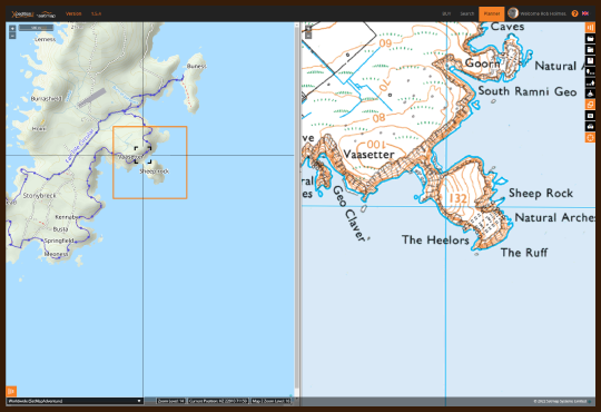
WIDEST RANGE OF MAPS
Choose the map that best suits your adventure
- Ordnance Survey Maps included
- Choose other maps for your adventure, including a wide range of countries
- Exclusive Adventure topographic maps for a clear,consistent worldwide view with a focus on features needed for outdoor activities
- A host of national map providers for your home country or trips across the globe.

ONLINE ROUTE PLANNING
Plan your perfect route for hiking, running, road cycling, MTB and more.
- Plan routes anywhere in the world wherever you’re online
- Large scale topographical maps in multiple formats to explore the area and make precise route choices
- Snap to track, bike or road according to your needs
- Plan a multi-stage expedition and view all stages on the map together
- Import a route, tailor it to your advanced route planning needs
- Share your route with friends or to any compatible device.
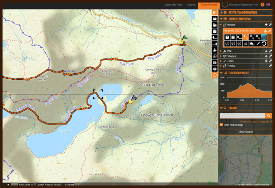
ADVANCED FEATURES
Developed with mountain experts to help you get the most from your outdoor adventures.
- Split screen to see the bigger picture alongside the finer details, OS alongside Aerial, whatever works for you
- Share to Garmin Connect with a single click
- View distance, ascent, decent and elevation data
- Add Points of Interest to highlight landmarks, meeting points, escape routes and more
- Combine, split or reverse routes.
- Print your route on the map to share as a pdf or hard copy back up
- Organise routes by expedition, region, activity etc.
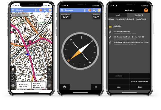
XPLORER GPS MOBLE APP
Integrated mobile app to navigate offline on your phone, even without signal
- Xplorer mobile app synchs automatically with your Xpedition2 routes
- Download your route and map, ready to navigate offline
- Follow a planned route or navigate spontaneously on the map
- Synch your activities with your Xpedition2 account
- Option to purchase an additional map for a special destination.
- Service and support terms


Where Will You Xpedition2?
Xpedition2 has advanced route planning features and topographic maps to give you the information you need to plan precisely the route you want to explore, with ease. Perfect for hiking, MTB, road cycling and even trail riding. Export your route to Garmin, Xplorer or your favourite navigation app. Adventures round the corner, or round the world – let Xpedition2 take you there.
Go Further With Xpedition2

Don’t forget you can now share an Xpedition2 route with your Garmin Connect account with a single click
Feedbacks from our users
MICHAEL
MARTIN
HADLEY
STEVE
TOM
I am already plotting my route to circumnavigate Mont Blanc next year to celebrate being 80. My motto “keep it all moving for as long as possible”
I have always loved maps from a small child and have a bookcase full of OS maps, but hardly ever look at them these days because of my amazing Xpedition2.
JOAN
KEVIN
Blog Posts
User Stories: Adventures In Scotland & Germany
It's always good to hear how Xpedition2 is helping our users have adventures.
Xplorer App – New Quick Start Guide
If you haven’t already, we’d encourage you to download our Xplorer app for when you’re out and about…
The Power of Regret
We’ve been discussing regret in the Xpedition2 office lately. If you've got the adventure itch then…